Copyright 2020 - 2021 irantour.tours all right reserved
Designed by Behsazanhost
Western Part of Fars province
Western Part of Fars province
The road leading to the western regions of Fars and farther on, to Bushehr, goes west from Shiraz, and after crossing a small ridge, enters the vast plain of Dasht-e Arjan (“the Plain of the Millet"). This plain is surrounded by high mountains and contains pastures much frequented by nomads. Formerly, the road passed through the scenic, but very dangerous Kotal-e Pirezan (“the Pass of the Old Woman"). The vertiginous descent in small hairpin curves was then followed by a climb to Kotal-e Dokhtar (“the Pass of the Maiden”), and then by another very steep descent to the plain of Kazerun, where a vast level stretch precedes a final descent to the coast. The current road bypasses the two famous passes, but a newer road with a great number of tunnels is being built along what is roughly the same route as the ancient roadway.
The most important cities of west Fars are:
Nurabad-Mamasani, Bishapur, and Kazerun.
Nurabad-Mamasani
Located in the northwestern part of Fars, the region of Mamasani occupies an area of about 15,000 sq. km. It is situated west of the Zagros mountain range at a height of 900 m above sea level. The center of the region - Nurabad - is located 165 km northwest of Shiraz. The Mamasani region is mountainous, and has a semi-arid climate, except for the part called Doshman Ziari; this enjoys more humid conditions. Watered by the largest local river of Fahlian and by numerous springs, it is an important center for rice cultivation in the area. Other crops are also raised here, and there is a good deal of stockbreeding. The main species of local flora are chestnut, mountain almond, and barberry trees, whose groves OCcupy about one-third of the entire region. There is also a rich assortment of herbs and grasses. Wildlife is represented by panthers, wild goats, mouflons, wild boars, hares, foxes, wolves, jackals, and bears. The region also has many different avian species, as well as a large variety of reptiles and invertebrates.
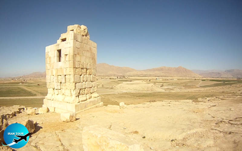 |
| Dragone's Column - Nurabad-Mamasani |
The history of Mamasani goes back at least 5,000 years ago. The region is known to have been a part of the Anshan realm under the Elamites. The Elamite bas-relief of Kurangun, dating from around 2,500 B.C. is among the best-preserved of the relics from this period. During the Median period, the region retained its importance, as clearly shown by the monuments of Dav-Dokhtar and Mil-e Ezhdeha. Mamasani seems to have gained an even more prominent status under the Achaemenid kings. The relics found in the town of Sarvan exhibit the same elements of Achaemenid architecture employed during the construction of Apadana palaces both in Susa and Persepolis and probably date from the time of Darius the Great. Mamasani remained part of the Anshan satrapy until the end of the Achaemenid rule. Some historians believe that the decisive battle between the army of Alexander the Great and the Iranian troops led by the famous general Aryo Barzan took place somewhere within the limits of modern Mamasani. By what name Mamasani was called during the Seleucid and Parthian periods, we do not know.
It seems probable that at that time the area was ruled by a king of some local dynasty, a vassal first of the Seleucid monarch, and then of the Parthian. Under the Sasanians, the area of Mamasani was an important part of the Shapur-khurreh. The basreliefs of Sarab-e Bahram and Naqsh-e Qandil are the most conspicuous works extant from this period in the region. After the fall of the Sassanid dynasty, the region of Mamasani (called Anburan at that time) was invaded by Arab troops. In 875, the area was occupied by the army of Yaqub Leis Saffarid, who won a final battle over the local forces in the vicinity of the White Fort. In the 10th century, the name of Anburan was abandoned, and the region became known as Shulestan. This name lived until the end of the 18th century, when following the final establishment of the Mamasani tribes there, the region began to be called by its modern name, Mamasani. This region was a field of numerous bloody battles during the 18th-20th century. Most of these took place between the locals rebelling against the government policies, and the army. The last rebellion, set off by the land reform initiated by Mohammad Reza Shah Pahlavi, occurred in 1964 and was severely suppressed.
Bishapur
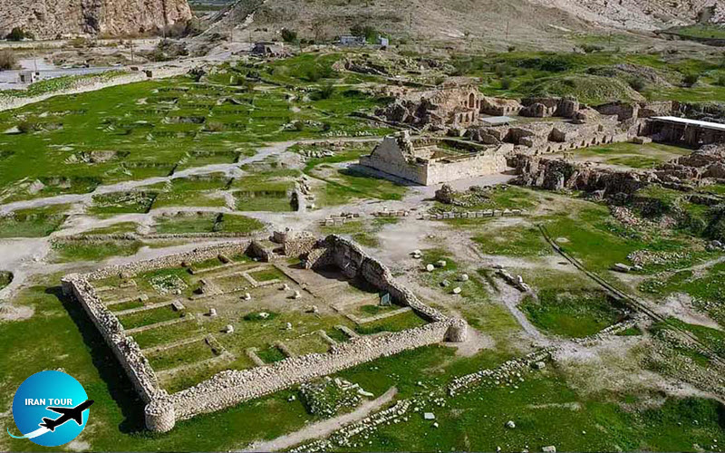
The ruins of Bishapur, one of the largest Sasanid cities, sprawl over a green valley on the southwestern bank of the Shapur River, near the point where it merges with the Sasan Spring, passing through the scenic Chogan Gorge. In addition to the beauty of its location, Bishapur had another great advantage. It was situated along the most important imperial roads, which under the Achaemenians linked Persepolis and Susa, and during the Sasanid period connected Estakhr and Ctesiphon. In its heyday, Bishapur successfully rivaled the most prosperous cities of the ancient world, including Byzantium and Antiochus, and by its later visitors were often given the sobriquet of the Sasanid Versailles.
 |
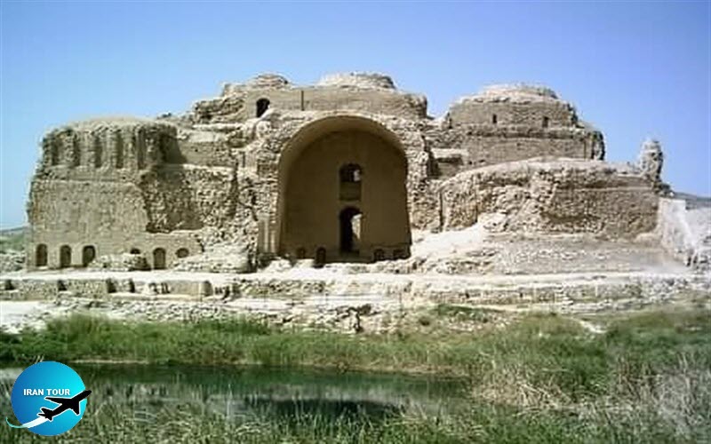
Bishapur was founded on the orders of Shapur I around 244, after his first victory over the Romans. From the very beginning, Bishapur has conceived achievements, rather than industrial or trade center. This being the case, the monarch spared no effort to bring about the town's prosperity and beauty. Bishapur was made the center of the smallest khurreh (a region of Fars during the Sasanid period), which also included Jerreh, Noubandan, and Kazerun. To provide additional revenue for the town, a royal mint was established, and coins were minted here throughout the Sasanid period, and even during the early Islamic age. Two written sources period, one an inscription on the memorial stele of Bishapur, the other, the Book of the Iranian Prophet Mani, testify to Shapur's admiration of his city. The king is said to have visited Bishapur in the middle of the construction work. He was so pleased with what he saw that he ordered the giving of rich gifts to the chief architect. Shapur is reported to have spent most of his leisure time in this, his favorite city, and is known to have died here.
In spite of the fact that Bishapur was unquestionably founded during Shapur's reign, the history of his town had already been forgotten by the middle ages. Some medieval historians reported that Bishapur had been in existence since the time of Tahmuras the Demon-Binder. They claimed that the town had been destroyed during the conquest of Alexander the Great and that Shapur had only restored it. Although I this is certainly a myth, the site may indeed have been populated in earlier times - as the Elamite cemetery, unearthed in the course of the recent archaeological excavations, serves to indicate. The architects and builders of Bishapur were principally Roman captives, mostly Assyrians, headed by a chief architect called Apsai. The first structures, which made up the Imperial District, were completed about 266 A.D. and consisted of the Temple of Anahita, the Mosaic Porches, and the Palace of Valerian. The other buildings, including I the Palace of Shapur, were added during the following years and were mainly completed before Shapur's death in 272 or a little later during the rule of his immediate successors. The last repairs and modifications of the Sasanid period were made in Bishapur during the rule of Shapur II. After his reign, the town seems to have been neglected, and many of its residents migrated to the neighboring Kazerun.
 |
At the time of the Arab invasion Bishapur put up strong resistance, headed by Shahrak, brother of the last Fars ruler during the Sasanid period (around 646 A.D.). Despite this, the town was soon forced to surrender. Bishapur was of paramount importance to the Arabs, who used Sasanid mints to mint their coins.
During the early Islamic period, the town's fortunes revived slightly, and this relative prosperity continued throughout the Buyid rule. After that, Bishapur was overshadowed by Kazerun; however, it retained its importance until it was devastated in 1066 by Abu Said Shabankareh, the Fars ruler, and finally razed in an earthquake two centuries later.
The name Bishapur (Weh-Shapur) is typical of the names the Sasanid kings gave to the cities they built, such as Weh-Ardashir, in which we may mean "home and domicile". However, the 14thcentury Arab historian Mostowfi claims that the name of Bishapur is derived from bana-ye Shapur, meaning "the foundation of Shapur”. Other authorities also held that bi is a contraction from both, meaning "god" or “great". During the early Islamic period, the name of the town was changed to Sabur, to avoid association with the name of the Sasanid king. Nonetheless, the name of Bishapur in its original form is frequently mentioned in the books of medieval geographers.
Bishapur occupies an area of about 180 hectares. Unlike most of its contemporary Iranian cities, which were built on a circular plan, Bishapur was laid out on a grid - a rectangular plan borrowed from the design of Greek cities. Two principal streets constituted the town's north-south and east-west axes. These crossed to form a square marked by two memorial obelisks, and during the Sasanid period, the square also held a statue of Shapur and two fire altars. The town had four gates: the Gate of Hormoz, the Gate of Mehr, the Gate of Bahram, and the Royal Gate. On the north, Bishapur was protected by | the river; it was spanned by only one bridge,
of which traces still remain. On the east, the town was dominated by the fortress of Qal'e-ye Dokhtar*, while the remainder of its perimeter was enclosed by
a rampart and a moat. The most important urban district was the Imperial; it occupied the eastern part of the city, which since the time of the 5th-century-B.C. Greek architect Hippodamus was believed to have the most favorable distribution of light and warmth. However, unlike Greek and Roman cities, the streets in Bishapur were not homogeneous but were made to differ from one another by means of variously-shaped arches, arcades, and passageways, the use of which imparted a unique appearance to every alley. In addition, the houses in Bishapur did not cling to each other with their back walls overlooking two parallel streets, as did Greek and Roman dwellings, but had a courtyard, often planted with trees. Because the town was never densely populated, its inhabitants could afford a garden around their houses.
 |
The west part of the town, reserved during the Sasanid period for the noblemen and the elite, was considerably expanded after the overthrow of the Sasanid dynasty; here the remains of mansions, mosques, and bathhouses from the Islamic period have survived. The changes which took place during the Islamic period, however, did not follow any particular plan; and every building was added to or amended at the whim of its owner. Although the principal changes took place outside the Imperial District, the palaces were still affected because the building materials for the new structures were often quarried from them. An elite town during the Sasanid period, Bishapur was adapted to meet the more plebeian needs of low-ranking traders, peasants, and workers. It is not, therefore, surprising to find that it never recovered the glory of its pre-Islamic period, and finally disappeared, yielding place to the nearby Kazerun. Its population never increased to the point of forcing the town's expansion beyond the limits of the initial Sasanid enclosure. Time was not merciful to this remarkable town. After it had been laid waste, Bishapur gradually turned into a huge earth mound. Archaeological excavations, carried on at great intervals since 1935, have revealed most of the ancient town, and the work is being continued in the interim.
Kazerun
Kazerun is located about 150 km from Shiraz and 170 km from Bushehr. It lies in a valley, 732 m above sea level, between two mountain chains, the Davan Mountain on the north and the Mast Mountain on the south. The region is rich in water, with Lake Parishan being the largest freshwater lake in Fars. The region has very hot summers, with a maximum temperature of 49°, and mild winters, with a minimum of 6o. The annual rainfall is about 400 mm. However, the climate of the town itself is more moderate. The main trees of the area are chestnut and cedar. Spacious pastures and mountain groves are responsible for the abundance of flora and fauna. Agriculture, horticulture, and cattle breeding are effectively developed. Among the main crops are wheat, barley, rice, citrus fruit, watermelons, and vegetables. In the past, Kazerun was famous as a textile-weaving center, but this craft has been abandoned. Modern handicraft products include carpets, pottery, Giveh (cotton shoes), and hand-made felt.
Undoubtedly, Kazerun was in existence prior to the Arab conquest. Scholars believe that it came into being as a settlement for common folk when Bishapur was founded for the country's elite. Its patriotic residents, however, credit its greater antiquity and tend to attribute the founding of Kazerun to the legendary Tahmuras the Demon-Binder. At different periods, the town was called Nurd, Dirist, and Rahban. Some authorities, however, claim that these were the names of three separate villages which merged into a single town at a later date. Kazerun acquired its present appellation in the 11th century. Some believe that its name derives from gaz, the cotton cloth that was woven here. Others suggest that the name is a distorted version of Kuh-e Zarran ("the Golden Mountain" - presumably so-called for its richness in minerals), at the foot of which Kazerun lay.
 |
During the Sasanid period, Kazerun constituted part of Shapurkhurreh*, whose capital was in Bishapur. At that time it had a large coin mint, which helped the town retain its importance after the fall of the dynasty. Kazerun had its heyday during the Buyid period when neighboring Bishapur had lost its prominent status. Azod al-Dowleh ordered the construction of a large market place in Kazerun. Skilled workers were brought from Egypt, and settled in the region to enhance the development of the textile industry. The water of one of the Kazerun qanats seems to have had a bleaching effect, a fact that made the white linen yarn produced here particularly valuable.
During the 13th-15th centuries, Kazerun played an important role as the center of the Ishaqiyeh (Morshidiyeh) Sufi order, the influence of which spread from Turkey to the Far East. This order was highly regarded by merchants, who also donated generously to the lodging places maintained by the dervishes. The order eventually dissolved with the establishment of Shiism by the Safavid dynasty. However, the tomb of its founder, Sheikh Abu Eshaq, remained an inviolable sanctuary. Another important Sufi, who lived and died in Kazerun, is Sheikh Amin al-Din. He was greatly praised by Hafez and Khaju Kermani. Khaju Kermani is even said to have spent numerous years in Kazerun serving as the Sheikh's disciple. The mausoleum of Amin al-Din, dating from the 14th century, has been largely rebuilt and today has nothing of artistic value except for its two tombstones, incised with verses from the Koran; one of the stones belongs to the Sheikh and the other to his successor.
At the end of the 18th century, the fortifications of Kazerun were dismantled, and the town suffered greatly from the disturbances of civil war. It has never since recovered completely, and today holds little to interest the visitor. However, it is a well-favored spot, agreeable and healthy in climate. Locals hope that with the completion of a new road running from Shiraz to Bushehr, and passing through Kazerun, the town's fortunes will be revived.
- Details
- Category: Shiraz Tourism