Iran Natural Landscapes
Each part of this ancient land has unique characteristics that distinguish it from other regions. This four-season land has very beautiful mountainous, forest and desert regions. Forests of northern Iran (Hyrcanian or Caspian forests) of approximately 1,488,000 hectares are located south of the Caspian Sea and along the northern slopes of the Alborz Range from Astarara to the west to Golestan to the east. These forests are part of deciduous broadleaved forests with a mild Mediterranean climate. In general, the forests of northern Iran have 80 species of trees, 50 species of shrubs, and hundreds of perennial grasses. You can use travel agency programs to visit Iran's forests.
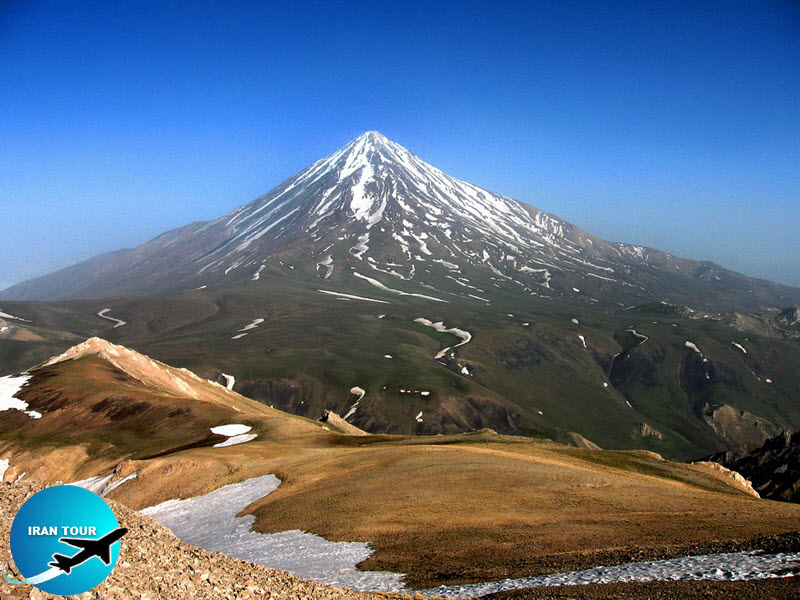
Mount Damavand
Mount Damavand is located north of Iran and is the highest volcanic mountain in the country and the highest volcanic elevation in the Middle East. It is located at the center of Alborz Mountain Range south of the Caspian Sea, near Amol. Lying in Mazandaran Province Mount Damavand can be seen from Tehran, Varamin, Qom, and Caspian Seashores when the sky is not cloudy. Mount Damavand was registered as the first national monument in Iran in the year 2008. Meanwhile, since 2002, this mountain has been classified as a national protected zone.
Mount Damavand first erupted in the Pleistocene almost 1.78 million years ago. After several known eruptions around 600,000 and 280,000 years ago, it finally erupted about 7300 years ago in the Holocene. Its steep cone is formed of ash and lava flows that are mainly made of trachyte, andesite, and basalt. The Quaternary lavas are directly located on the Jurassic sediments. The volcano is crowned by a small crater with sulfuric deposits. There are also fumaroles, hot springs, and mineral deposits of travertine. Mount Damavand could be considered as a potentially active volcano, since there are fumaroles near the summit crater emitting sulfur, which were known to be active on July 6, 2007.
Mount Damavand has been repeatedly mentioned in Iranian mythology and its fame lies in the fact that Zahak, a legendary cruel and demonic king, is chained on its peak. Damavand is the symbol of Iranian resistance against despotism and foreign rule in Persian poetry and literature. In Zoroastrian texts and mythology, the three-headed dragon Aži Dahaka was chained within Mount Damavand, there to remain until the end of the world. In a later version of the same legend, the tyrant Zahhak was also chained in a cave somewhere in Mount Damavand after being defeated by Kaveh and Fereydun. Persian poet Ferdowsi depicts this event in his masterpiece, the Shahnameh. The mountain is said to hold magical powers in the Shahnameh. Damavand has also been named in the Iranian legend of Arash as the location he fired his arrow to mark the Iran border. The famous poem Damavand by Mohammad Taqi Bahar is also one fine example of the mountain's significance in Persian literature.
There are many hot springs gushing from this mountain. The most important of these hot springs is located in Abe Garm Larijan in a village by the name Larijan in the district of Larijan in Lar Valley. The water from this spring is useful in the treatment of chronic wounds and skin diseases. Near these springs there are public baths with small pools for public use.
The best major settlement for mountain climbers is the new Iranian Mountain Federation Camp in the village of Polour, located on the south of the mountain. There are at least 16 known routes to the summit, with varying levels of difficulty. Some of them are very dangerous and require rock climbing. The most popular route is the Southern Route which has step stamps and a camp midway called Bargah Sevom Camp/Shelter at 4220 m (about 13,845 ft). The longest route is Northeastern and it takes two whole days to reach the summit starting from the downhill village of Nandal and a night stay at Takht-e Fereydoun (elevation 4300 m - about 13,000 ft), a two-story shelter. The western route is famous for its sunset view. Simorgh shelter in this route at 4100 m (about 13,500 ft) is a newly constructed shelter with two stories. There is a frozen waterfall/Icefall (Persian name Abshär Yakhi) about 12m tall and the elevation of 5100 m is the highest fall in Iran and the Middle East.
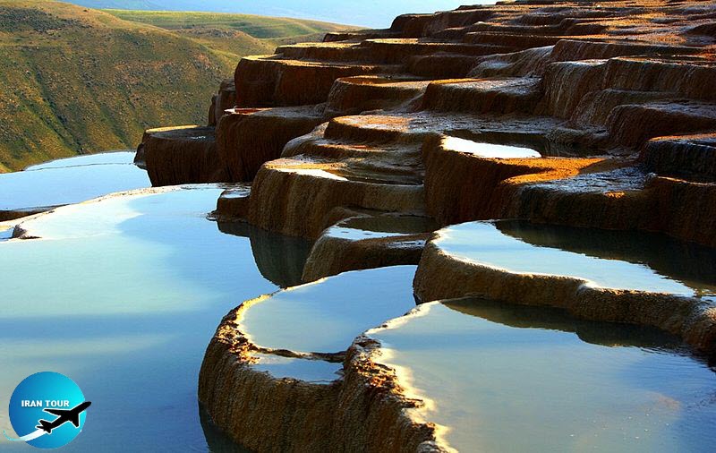 |
Badab Surt springs
Badab Surt springs in Mazandaran are two springs with waters completely different from the point of view of color, odor, taste, and volume. The first spring which has ample water has very briny water and a deep pond with 15 m diameter. The second spring, above the first spring and in the north, has soar water with red and orange color. The mineral sediments driven out from these two springs during the course of years have been accumulated at lower elevations of the mountain and have created hundreds of deposits and dozens of lovely ponds in orange, yellow and red colors. These deposited minerals and ponds are in fact rare and attractive scenes around Badabsoort springs. The beauty of these deposits and the natural position of the springs in the mountainside and the surrounding landscapes are very charming, especially during sunset. The springs are located at an elevation of 1840 m from sea level and are unrivaled in beauty in the country. Only Pamookaleh Spring in Turkey resembles Badabsoort Springs in beauty. The area above the springs is covered by barberry and coniferous jungles.
How to travel to Badab Surt or seven colors springs
The beautiful springs, also known as colorful springs, attract many tourists, and we can see many of them. Badab Soort, Lout Desert, and Abarkuh Cedar were registered as three natural works by the Cultural Heritage Organization. Surat Spring is the second largest spring water source in the world after Pamukhal Spring in Turkey.
Characteristic
Badab Sourt's fountains include two fountains with water completely different in terms of color, smell, taste, and amount of water. The causa spring has very salty water with a depth of about 15 meters in diameter, which is mainly used for water in summer and is useful for the treatment of back pain.
The natural landscape of the forest and mountains are around and far away. The most fantastic scenes in the region during sunrise and sunset are when the light shines in the pools. These springs are located at an altitude of 1840 meters and are unique in Iran. The countries of Turkey, the United States, and New Zealand have similar springs.
Access roads
To get to Orost village from Tehran, you can use the roads of the province of Semnan or Mazandaran in the following order. Of course, Semnan province roads are less distant and safer, but Mazandaran province roads are much more beautiful:
Routes
1: Tehran, Semnan, Mahdishahr, Shahmirzad, Steel Road, Three Way Telmadra, Orost village, Badab Surat Route
2: Tehran, Sari, Kayasar, Telmadra Road, Orost Village, Badab Surat From Semnan and San towns to Orost village, the road is fully paved, and it is a dirt road from the village to the incredible springs of Badab Sourt, one kilometer east of the town.
Tang e Boragh
Tang e Boragh is the name of a pretty valley near a village of the same name at Sadeh District, Eghlid town, 190km north of Shiraz. One can see herbs in this valley that form natural light shed on walls river flowing in this valley Iver has cut a 40 m passage m height on the mountain. valley there is beautiful water drop from the caves and crevices. The deep river flowing in the joins Kor River. This river has cut a 40 m with vertical walls of 100 m height on the mo At the rocky left side of the valley there is a cave with lime deposits. Water drops from the ceiling onto the floor like rain. The floor and the w of the cave are covered by algae. Amid dense and tall trees, springs, rivers, pretty caves, and wale the lime columns have created rare scenes. Other important interesting sites in Tang e Boragh one can refer to a tablet in Pahlavi script, an ancient district in the village, a natural cave, and Molla Sadra Lake.
Maragheh Fossils
The fossils in Maragheh represent 7 million years of history and are one of the ancient natural features in Iran. In the latest studies conducted by Iranian and foreign archeologists in this area the fossils of the ancestors of mammoths, zebras and deer have been discovered. The fossil layers near Maragheh belong to the end of the Cenozoic Period. Mammoth fossils in Maragheh Fossils Resort are universally known and are being carefully protected. About a century ago the bones discovered in Maragheh were thought to belong to prehistoric man, horned horses, and demons, but later on, they were found to be prehistoric mammoths and similar giants. Studies conducted in the last century by domestic and foreign archaeologists in this region point to the existence of fossils of giant vertebrates. Maragheh Fossil Paradise is the name given by fossil connoisseurs to this region. The fossils of the vertebrates in Maragheh have attracted the attention of foreign geologists and researchers.
Sahoolan Cave
Sahoolan Cave is located 42km northeast of Mahabad. West Azerbaijan Province. The elevation of the Cave from the ceiling to the surface of the lake is 50 m and the depth of the lake sometimes reaches 30 m. The temperature inside and outside the cave varies from 10 to 15 degrees centigrade. Sahoolan means frozen in Kurdish language. The local people call the cave Khoone Kootar meaning pigeon nest because many pigeons have nestled in it.
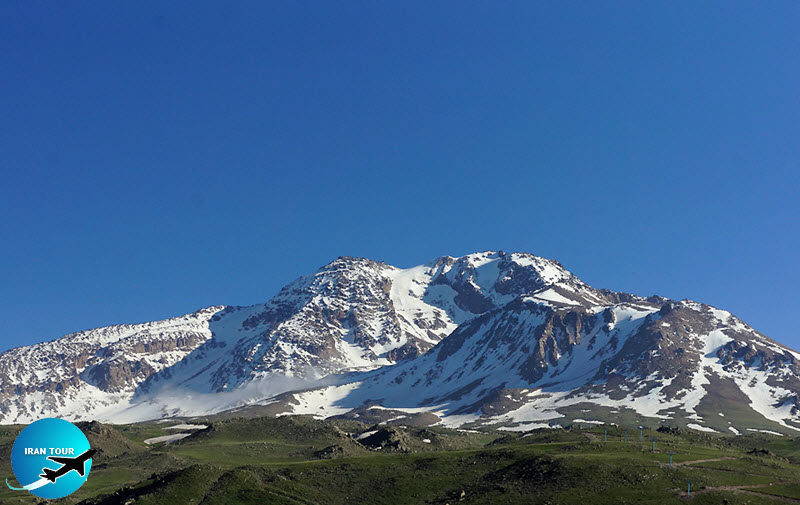
Mount Sabalan
Sabalan, located northwest of Iran and Ardabil Province, is one of the lofty mountains in Iran. The height of Mount Sabalan is 4811m from the sea level and is the highest mountain peak in Iran after Mount Damavand and Alamkuh mountains. It is an extinguished volcanic mountain with a small lake near the peak. Thanks to the hot springs gushing at the mountainside Sabalan is very pretty in the summer and tourists love its ski resort.
Yakhkan Cave
Yakhkan Cave is located on the southern edge of Ardabil Province at a height of 2500m and about 60m below the mountain summit. Its soil is made of lime. One can see shattered stones outside the cave which is the result of the freezing temperature outside the cave. The mouth of the cave is very small (50 cm) and the visitor must pass a narrow corridor of 10 m in length and 50 cm in width to reach a big auditorium. The length of the auditorium is 36 m and the width is 15 m and its height is approximately 20 m. The air is very cold and moist inside the cave. There is a pond at the east side of the cave 1.5 m above the floor in which the water is accumulated from molten snow. The water in the pond is very sweet and cold. The main auditorium is connected to smaller halls through several corridors. One outstanding feature of this section is the continued flow of moist air which has formed icicles and thin ice sheets on the ceiling and the walls. The cave is called 'yakhkan' which means ice mine because of being very cold. Interestingly enough water freezes in the cave when the outside weather is warm and begins warming and melting when it is cold outside. The peasants in Gandomabad, Jalalabad, and Roknabad get their ice from this cave in the summer. They believe that water has a healing effect.
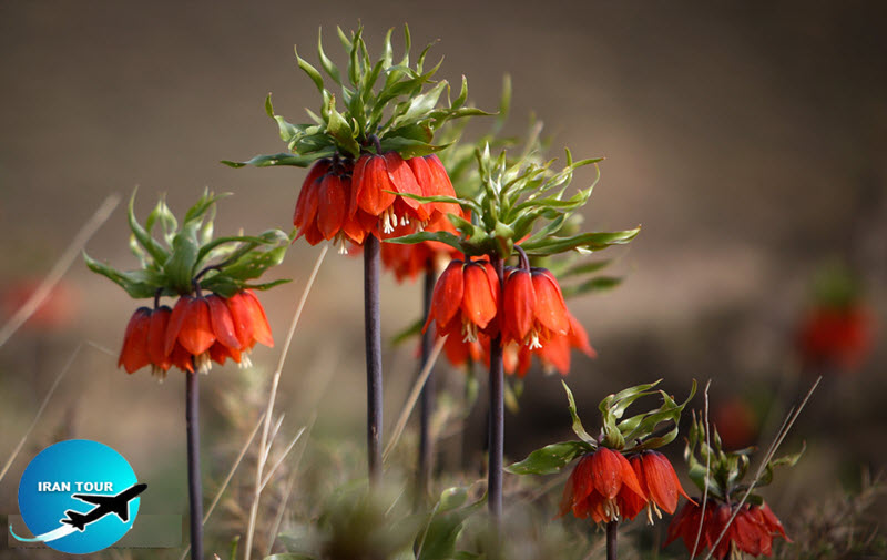 |
Inverted Tulips
The Inverted Tulips Plain is a very attractive site for tourists. It is enlisted among 20 natural monuments in Iran that are protected by the Environment Protection Organization. The plain lies in Chaharmahal & Bakhtiari Province and covers an area of 3600 hectares and is the main habitat of inverted tulips. The plain neighbors Kuhrang town. Kuhrang Waterfall, Chalgard Ski Resort, and Dimeh Mineral Spring are interesting sightseeing places near Inverted Tulips Plain. The real habitat of this rare flower is Abkassekhorbeh, Gorganak, Bonovasteki, and Malehzardeh mountains. Inverted tulips blossom at the beginning of March and wither away in mid-May.
Pirgel mud spraying spring
Pirgel mud spraying spring is located 85 km south of Khash, Sistan and Baluchestan province. Mud spraying is an interesting process. It happens when the sea ebbs and flows and the mud is driven out! of the sea and spread over three hectares of land. No plants are growing in the accumulated mud.
Mount Taftan
Taftan is the only active volcanic mountain throughout Iran. This mountain is located southeast of Iran in Sistan & Baluchestan Province. The summit is approximately 4000 m above sea level and is the highest mountain peak southeast of Iran. Khash is the nearest town to Taftan Mountain. In the Persian language 'Taftan' means a warm place. The volcano at Taftan Mountain is active and sulfur gases issue from its mouth. Mountain climbers climb the mountain from the western flank in which a well-equipped shelter has been built. Due to severe cold winds, it is impossible to climb Mount Taftan Peak in winter.
Soosan Chandelier
Soosan Chandelier is a rare lily growing only in Damash Village in Gilan and Azerbaijan Republic. It is the first plant in Iran whose habitat has been registered as a natural habitat by the Environment Protection Organization.
Harzevil Cypress
Tree Harzevil Cypress Tree is located north of Manjil in Gilan Province. This cypress tree is very ancient and has been mentioned by Nasser Khosrow in his travelogue. It is a natural monument and is being protected by the Iranian Environment Protection Organization.
 |
Blind Fish Cave
This cave is located in Lorestan Province, Papi District, near Loon village. There are two types of rare blind fishes in this cave that have not been spotted in any place in the world. This fish is completely blind and has nothing on its head to show eyes. It is called blind fish because it lives in underground waters in dark caves.
Chalnakhjir Cave
Chalnakhjir Cave is located 8 km northeast of Dilijan in the Markazi Province. The cave is divided into the main auditorium and several halls. So far the local authorities and cave lovers have explored only 4 km of the cave.
Khoshkedaran Jungle
Khoshkedaran Jungle is located 30 km away from Tonekabon town leading to Chalus and is 120 m away from the Caspian Sea. This protected zone is the only virgin jungle that covers an area of 2.6 million sq. m and is the only prairie jungle north of Iran. Many plants such as alder, pomegranate, beech, oak, box trees and wild jasmine are growing in this jungle. Various sorts of animals have lived in this jungle and right now jackals, wolves, pigs, wildcats, goose, ducks, herons, etc. roaming in the jungle. Thanks to such rare attributes and being adjacent to the lovely shores of the Caspian Sea and tourist-attracting towns and suitable guesthouses Khoshkedaran Jungle is one of the loveliest jungles for the inspection of sightseers. A museum of natural history has been built near this jungle which displays taxidermy of wild animals north of Iran and is frequently visited by researchers and scientists with the help of the Environment Protection Organization.
Alamkuh Mountain
Alamkuh, 4850m high and the second tallest mountain in Iran, is located 20 km southwest of Kelardasht town, in Mazandaran Province.
Takhte-Soleyman Peak
Takhte-Soleyman or Mazandaran Peak is 4659 m above sea level and is located west of Alborz Mountain Range and Alamkuh Mountain.
Khersin Salt Cave
Khersin Cave is one of the famous natural salt caves in Hormozgan Province 80km away from Bandar Abbas. Most of the rocks in the cave are made of soft salt which easily crumbles down. The height of the mouth of the cave is 3m, the width is 4m and the length is 178m. After walking a few steps inside the cave the visitor reaches the only auditorium of the cave. After advancing 10m in the auditorium you arrive at a narrow lane on the left side which leads you to the cave's main corridor. The corridor has no branches and takes you to a length of 170m inside the cave. When entering the cave you can easily notice the upward slope which continues to the end of the cave. A salty stream flows in the cave. Thanks to a sharp slope the stream it gathers pace in winter and rainy seasons and flows fast out of the cave. After one hour of walking, you reach the end of the cave. A salty waterfall of 12m in height can be seen in the middle of the cave. Rainfall seldom falls at the beginning of spring and summer and it is the best time to visit the cave. Because of crumbling walls, we do not recommend you to visit the cave in rainy seasons. The water in the cave is not potable. Meanwhile, you must observe safety rules to escape harm.
Jashak Salt Dome
Salty Jashak Dome (or mountain) in Bushehr Province is one of the biggest and prettiest salt domes in Iran and the Middle East which has been registered as a natural monument. Jashak Dome is located 144 km southeast of Bushehr; 55 km away from Khormoj town and 15 km away from Kaki town. The peak of this salty dome is 1350 m from the neighboring plain. This mountain is 12 km long and 4.5 km wide and the dome covers an area of about 3666 hectares and its peak is 1350 m above sea level.
 |
Abarkuh Cypress
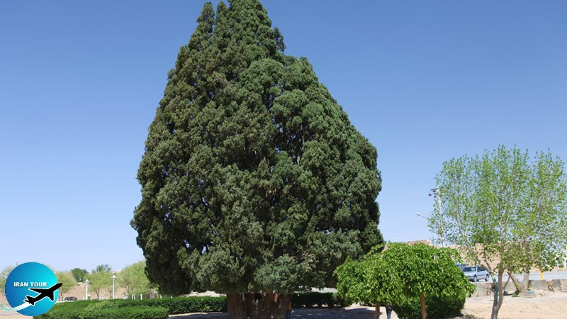
Tree Abarkuh Cypress Tree is located at Abarqoo town and is one of the oldest trees in the world. The circumstance of its stem near the ground is 11.5 m and its height is between 25 to 28 m. In a travelogue written in the 13th century Hamdollah Mostofi, an Iranian historian, says, there is a cypress tree in Abrkuh which is famous in the world. Alexandrov, a Russian scientist, believes the cypress tree is 4000 years old. Some say the ancient tree has been planted by Prophet Zoroaster. Others say it was planted by Noah's son. In a report about the ten oldest trees in the world, China Daily says the cypress tree in Abrkuh is the second oldest tree in the world after Mosooselah Tree which is 4800 years old.
Abr Jungle
Abr Jungle or Cloudy Jungle is one of the oldest and prettiest jungles in the country and a rare and unique habitat of herbs and animals. The jungle is located 50km northeast of Shahrood town, Semnan Province. It is called Cloudy Jungle because most of the time the jungle is covered by dense clouds. The clouds are so close to the trees in the jungle as if one can fly among them.
 |
Rigjen Sandy Desert
Rigjen (meaning devilish sands) is a small desert full of sand dunes and mounds inside the Markazi Desert in Iran. Rigjen Desert is located south of Semnan, east of Salt Desert, north of Anarak, and west of Jandagh village. It is the most difficult dessert to pass in the world. In the past caravans and desert travelers never passed through this desert and still, there is no village or path in it. No one goes there except scientists and researchers. Our ancestors believed that Rigjen Desert was the dwelling place of evil spirits and devils.
Shahdad Sandy Desert
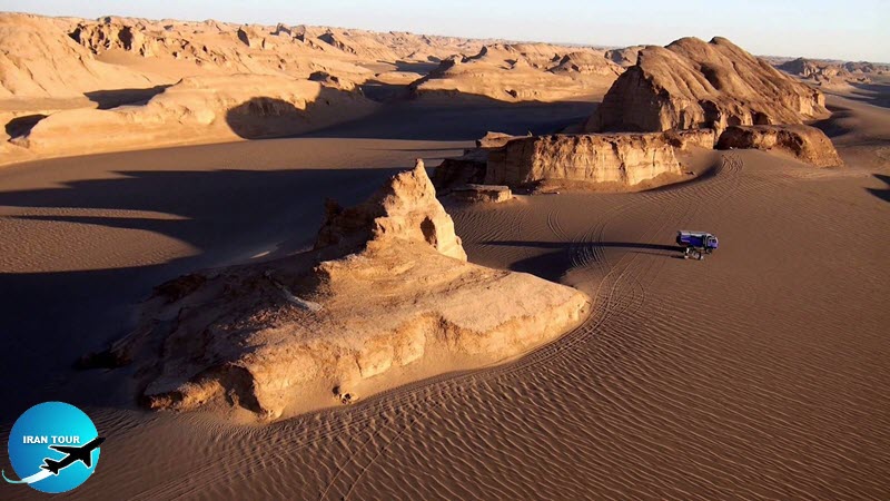
Shahdad Sandy Desert is located 45 km northeast of Shahdad town and covers an area of 11 thousand square km. Shahdad Sandy Desert is a very interesting national phenomenon. The mounds in the desert are the result of the gradual erosion of hills in the course of centuries. They envelop the fabulous Shahdad town in the heart of the desert. There is a place in this desert called "Gandomberian (burnt wheat region) in this desert, said to be the hottest place on earth, which is covered by black lava and because of blackness it gathers more heat than other places in the desert.
Ali Sadr Cave
Ali Sadr Cave is the biggest lake cave in the world. The cave is located 75 km from Hamadan. The elevation of the cave from the sea level is 2100 m. The cave has many winding corridors and lobbies. The streams running from different directions have joined each other and have formed a big lake in the cave. Travelers can cruise in the cave only by boat. Ali Sadr Cave is a famous tourist-attracting destination in Hamadan Province.
