Copyright 2020 - 2021 irantour.tours all right reserved
Designed by Behsazanhost
Kazerun Historical Sites
Kazerun
Kazerun has located about 150 km from Shiraz and 170 km from Bushehr. It lies in a valley, 732 m above sea level, between two mountain chains, the Davan Mountain on the north and the Mast Mountain on the south. The region is rich in water, with Lake Parishan being the largest freshwater lake in Fars. The region has very hot summers, with a maximum temperature of 49°, and mild winters, with a minimum of 6o. The annual rainfall is about 400 mm. However, the climate of the town itself is more moderate. The main trees of the area are chestnut and cedar. Spacious pastures and mountain groves are responsible for the abundance of flora and fauna. Agriculture, horticulture, and cattle breeding are effectively developed. Among the main crops are wheat, barley, rice, citrus fruit, watermelons, and vegetables. In the past, Kazerun was famous as a textile-weaving center, but this craft has been abandoned. Modern handicraft products include carpets, pottery, Giveh (cotton shoes). and hand-made felt.
Undoubtedly, Kazerun was in existence prior to the Arab conquest. Scholars believe that it came into being as a settlement for common folk when Bishapur was founded for the country's elite. Its patriotic residents, however, credit its greater antiquity and tend to attribute the founding of Kazerun to the legendary Tahmuras the Demon-Binder. At different periods, the town was called Nurd, Dirist, and Rahban. Some authorities, however, claim that these were the names of three separate villages that merged into a single town at a later date. Kazerun acquired its present appellation in the 11th century. Some believe that its name derives from gaz, the cotton cloth that was woven here. Others suggest that the name is a distorted version of Kuh-e Zarran ("the Golden Mountain" - presumably so-called for its richness in minerals), at the foot of which Kazerun lay.
During the Sassanid period, Kazerun constituted part of Shapurkhurreh*, whose capital was in Bishapur. At that time it had a large coin mint, which helped the town retain its importance after the fall of the dynasty. Kazerun had its heyday during the Buyid period when neighboring Bishapur had lost its prominent status. Azod al-Dowleh ordered the construction of a large market place in Kazerun. Skilled workers were brought from Egypt, and settled in the region to enhance the development of the textile industry. The water of one of the Kazerun qanats seems to have had a bleaching effect, a fact that made the white linen yarn produced here particularly valuable.
During the 13th-15th centuries, Kazerun played an important role as the center of the Ishaqiyeh (Morshidiyeh) Sufi order, the influence of which spread from Turkey to the Far East. This order was highly regarded by merchants, who also donated generously to the lodging places maintained by the dervishes. The order eventually dissolved with the establishment of Shiism by the Safavid dynasty. However, the tomb of its founder, Sheikh Abu Eshaq, remained an inviolable sanctuary. Another important Sufi, who lived and died in Kazerun, is Sheikh Amin al-Din. He was greatly praised by Hafez and Khaju Kermani. Khaju Kermani is even said to have spent numerous years in Kazerun serving as the Sheikh's disciple. The mausoleum of Amin al-Din, dating from the 14th century, has been largely rebuilt and today has nothing of artistic value except for its two tombstones, incised with verses from the Koran; one of the stones belongs to the Sheikh and the other to the his successor.
At the end of the 18th century, the fortifications of Kazerun were dismantled, and the town suffered greatly from the disturbances of the civil war. It has never since recovered completely, and today holds little to interest the visitor. However, it is a well-favored spot, agreeable and healthy in climate. Locals hope that with the completion of a new road running from Shiraz to Bushehr, and passing through Kazerun, the town's fortunes will be revived.
 |
-Nazar Garden
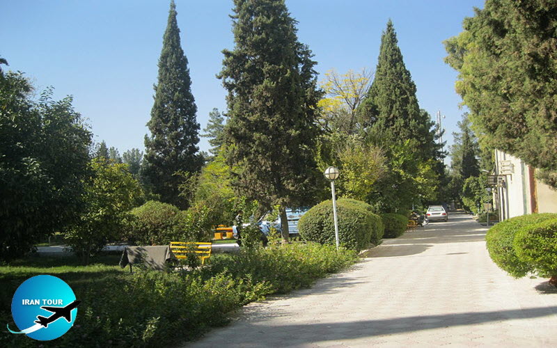
A famous garden showpiece in times past, today the Nazar Garden(same name in Shiraz) is hardly more than a simple town park. It was laid out in the 18th century by Khajeh Ali Qoli Khan, the local governor under Nader Shah. His son (or nephew, according to other sources) and successor to this lucrative post, Khajeh Hessam al-Din, built a Qanat, the water of which was used for the garden. The garden was long a place where local rulers received their distinguished guests, and some of these guests left enthusiastic reports of the site. Today the pavilion holds temporary exhibitions.
 |
-Alameh Davani's Tomb
Davan is an almost deserted ancient village in the suburbs of Kazerun. It is known principally as the final resting place of Allameh Davani, the great 16th-century scientist, sage, and jurist, who was born here and died here. His mausoleum greatly resembles a Sasanid-period building, although it is obvious that it has been repeatedly rebuilt, and that the modern structure has deviated greatly from the original design. The crypt consists of a domed tomb-chamber, flanked by vaulted corridors and fronted by an arcade; there seems to have been a small chamber at either end of the arcade. The ruins of a minaret antedate the structure itself and provide additional evidence that the mausoleum was modified at a later date. There are many tombs throughout the shrine's precincts. One of the tombs is marked by a lion, symbolizing the bravery of the deceased, a tradition that persisted among the nomadic tribes of western Iran.
-Pir Bonaki
The village of Kamaraj, located southeast of Kazerun, is famous for its cereals and dates, as well as for the weaving of shawls. Its only place of interest is a plain crypt, probably belonging to some revered person or local authority. This is a small square structure surmounted by a round dome. The building appears to be comparatively modern. It is best known for the tree which has established a comfortable foothold on its roof.
 |
-Bas-relief of "the Bridge of Mirror"
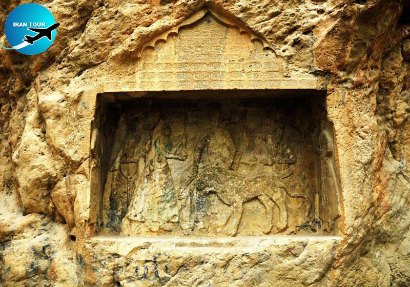
Pol-e Abgineh ("the Bridge of Mirror”) marked the natural entrance to the Kazerun Plane at the time when travelers used the road which passed through Kotal-e Pirezan and Kotal-e Dokhtar. The place is interesting only for the Qajar-period carving on the wall of rock soaring above the road. This bas-relief is one of those degenerate imitations of the Sasanid model in which the Qajar princes loved to indulge. The hero depicted in this case is Timur Mirza, the governor of Kazerun and the son of Hossein Qoli Mirza, a son of Fathali Shah, and the Governor-general of Fars. In the verse engraved above the scene, he is also called Timur Shah, which was the title generally applied in the latter half of Fathali Shah's reign not only to the monarch's elder sons but also to his other male descendants.
The prince is shown sitting on the throne; beside him on the left is a lion on a chain leash. The chain is clearly visible on the front of the animal's chest, and the prince has placed his left hand behind the lion's neck. On the prince's right-hand side is depicted Mohammad Khanollah, an attendant, and on his left-hand side, beyond the lion, is Manuchehr Khan, who is presenting a water pipe to the prince. The figure of the rifleman, Khosrow Khan, is on the sidewall on the right-hand side, and there is another, undistinguished figure on the opposite wall on the left-hand side. The figure of a hunter is also carved on the left-hand side outside the scene. A hawk completes the array of personages portrayed. The figures are more than life-sized and were originally painted. The master sculptor who carved the scene was named Ahmad. Vesal of Shiraz composed the verses, which extol Timur Mirza's prudence, and which were inscribed by Abbas ibn Yahya. From the numerical value of the letters of the hemistich, the date of the year is shown as 1829, which is five years before the end of Fathali Shah's reign.
The carving was almost obliterated not many years after its completion, a testimony to the dislike entertained toward the Qajar dynasty in the middle of the 19th century. This feeling must have impelled the nomad tribes - together with every passing wayfarer - to inflict whatever defacement they might upon the likeness of the vainglorious Timur.
 |
-Kazerun Fire Temple
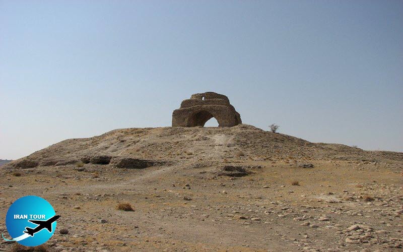
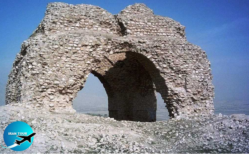
The fire temple of Kazerun, located about 10 km southeast of the town, is believed to be one of the five famous fire temples built in western Fars by Mehr-Narses, the renowned vizier of several Sasanid kings. Standing today are only two of its piers, supporting a round arch, while the rest of the building has crumbled to dust. However, because the structure is built on a typical Chahar-Taq plan, it is relatively easy to recreate its original shape. It seems that the fire temple consisted of four corner piers, which supported four-round, open arches on either side of the cubic building, and was crowned by a turnip-shaped dome. The building materials were stone and gypsum mortar. Each wall, about 4 m high and more than 1 m thick was about 8 m long on the outside and 6 m long on the inside. The structure would have looked even more impressive with the dome, the dimensions of which have not been established. The arches spanned about 2.5 m, and the height from the ground to the apex of the arches was about 3 m. At a short distance from the fire temple, a deep well and a water tank provided water for the structure.
-Sar-Mashhad
The Sar-Mashhad Plane is about 30 km long and 9 km wide. On the east and west, it is bounded by high mountain ranges, and Mt. Sarvak on the west separates Sar-Mashhad from the Bospar Plain, where Gur-e Dokhtar (see below) is situated. Many stone ruins from ancient ages, as well as archaeological mounds, are scattered throughout the plains, and these convince the traveler that in former times this region was much more populated and flourishing than it is now.
-Bas-relief of Bahram II and the Sasanid inscription
On the breast of the mountain in the western part of Sar-Mashhad, at an elevation of some 25 m above the ground are carved an inscription in Sasanid Pahlavi script, done at the order of Kartir, and also a basrelief of Bahram II. The inscription is engraved above the royal scene, a little towards the right. The longest inscription of the Sasanid period, it presents a complete record of Kartir's feats aimed at the consolidation of the Zoroastrian creed. It also gives a description of the priest's intriguing career, speaks of the punishment of those whom he considered sinful, and praises those whom he deemed virtuous The second part of the text runs in quite a different vein, being concerned with eschatological questions. As one of the earliest documents of its kind in Pahlavi literature, it is of the greatest importance. Unfortunately, the text is too badly mutilated. Nevertheless, enough remains to make it clear that Kartir is describing a vision of "the Beyond” which the gods have granted to him, and is setting forth his doctrines on heaven and hell, thereby justifying the religious measures he had taken. Somewhat abridged copies of this inscription have been carved at Naqsh-e Rajab and Naqsh-e Rostam.
The bas-relief is about 5 by 2.5 m in size and dates approximately from 390 A.D. Although the scene has been largely eroded, enough has survived to exhibit the skillful craftsmanship of its carvers. The relief portrays Bahram II, protecting the queen and his son from the attack of two lions, and Kartir is shown behind the principal group. As in other carvings of this Sasanid king, Bahram wears graceful, flowing robes. His crown is decorated with a wing on either side and is surmounted by a very tall turban. Bahram's left hand is extended towards the queen, who holds the king's hand with her own right hand. One of the two lions is depicted as having been killed and having fallen under Bahram's feet. Another lion has sprung up to attack the king but has been stopped by the monarch, who has thrust his dagger into the lion's chest.
-Jereh Fire Temple
One of the fire temples whose construction is ascribed to Mehr-Narses, it is a very large and relatively intact Chahartaq. Built of stone and gypsum mortar, it rises about 14 m high and stands on a hill. overlooking the Jereh River. Evidence testifies that a town once existed around this temple.
-Farashband
Sasanid Chahar-Taqs are usually isolated structures. However, in one region of Fars, the traveler comes across an entire cluster of them. The suburbs of Farashband exhibit an astonishing number of fire temples. The construction of some of these is believed to have been undertaken at the order of the celebrated Mehr-Narses. The medieval Islamic historian Tabari wrote: "Mehr-Narses built lofty buildings in Dashtbarin and Jerreh, and he made a fire temple in the village of Ab-e Ravan (reportedly Mehr-Narses's birthplace] which was still standing several centuries after the dissolution of the Sasanid dynasty. Near the village of Ab-e Ravan he built four other villages, in each of which a fire temple was constructed, and one of them he designated as his own and called it Faraz Mara Avar Khozaya.
Three other fire temples he named Zarvandazan, Kardaran, and Magoshnaspan, after his three sons, the eldest being Zarvandaz, and the other two, Kardar and Magoshnasp, whom he had trained for three important posts in the country. In this same area he laid out three gardens, in the first of which he planted twelve thousand date palms; in the second, twelve thousand olive trees; and in the third, twelve thousand cypresses. All these villages and gardens and fire temples remained until the third Islamic century in an excellent state, and were administered by people descended from him.” Of these five fire-temples, two have been identified as the Kazerun Fire Temple and the Jereh Fire Temple (see above), while three others are presumed to have been located around Farashband. These Chahar Tags greatly resemble one another in the building materials used, in the style of construction, and in their dimensions. Undoubtedly, there were also other fire-temples in this area, and the medieval geographer Estakhri testifies that every village had its own shrine.
-Farashband Fire Temple
-A four-arched building with a vestibule on either side, this fire temple measures externally about 8 by 10 m. The interior square core is roughly 5 m on a side, and the original height of its four piers is about 6 m. Much of the structure has tumbled down, but the piers, part of the dome, and two outer walls still remain. The structure is built of rubble stone set in gypsum mortar, and its outer walls reveal the traces of the cut and polished stone that may have been applied to its facade. There are no buildings adjacent to the main structure; these have either disintegrated completely or never existed.
 |
-War Trap Fire Temple
This fire temple consists of several structures. The main edifice is a square Chahar-Taq, bordered by a vestibule on either side. It was possibly the place where the sacred fire was kept. The interior dimension of the building's walls is about 5.5 m on a side, while on the outside, each wall is almost 9 m long. Together with the surrounding vestibules, | each side of the building reaches about 16 m. Round arches with a span of about 4.5 m pierce each side, and the width of the opposing openings in the vestibules is 1.6 m. The outer wall of the northeastern side of the building has completely disintegrated, and the arch of the vestibule of that section has also fallen.
The auxiliary section consists of two square structures of similar size. These may have been places where priests or pilgrims lived, and where the articles used in the ceremonies were stored. The structure at the western corner has almost crumbled away, but its ruins indicate that in size it matched the structure at the southern corner. Both contained two identical, rectangular rooms with barrel roofs. The doorways of the structures opened toward the main building and the courtyard.
-Drum-House Fire Temple
This fire temple has remained in comparatively fine condition. On one side, the square core has been extended by a wall, which forms a rectangle about 11 by 8.5 m, and 10 m high. The building is made of smooth stone and gypsum mortar. At a short distance, a wall about 1.5 m high is still standing; this wall apparently was part of the living quarters of a fire-keeper or pilgrims' lodgings.
 |
-Gür-e Dokhtar
According to present-day maps, “The Maiden's Tomb” is located in the province of Bushehr, but it is best visited during the trip to Sar-Mashhad and Farashband. The road spins through the mountains dividing western Fars from the Persian Gulf coast and is very unpleasant. Moreover, because the structure itself is surrounded by scaffolds at present, a visit to it may be put off till more propitious times. Although resembling in shape and masonry the Mausoleum of Cyrus the Great at Pasargadae, Gur-e Dokhtar is inferior, as compared to its much more famous counterpart. It is a rectangular building with a pointed roof and standing on a three-stepped platform. The platform measures about 5.5 m long, 4.5 m wide, and 1 m high. The exterior dimensions of a tomb-chamber built atop the base are slightly more than 3 m long, 2 m wide, and 1.5 m high. The entrance to the chamber faces northwest and may have been closed by a stone door, which has long disappeared. The sepulcher chamber is empty today. Its flat ceiling consists of two large slabs. The niche below the pediment may have borne a funerary inscription. The original roof may have had two ridges at an angle paralleling that of the gables.
The structure is built of large stone slabs, laid one upon another without mortar. The walls and roof of the chamber are composed of nineteen layers of stones of varied dimensions. One-piece, which originally supported the back of the tomb, was brought down and broken by nomadic tribesmen during their intense treasure hunt. It is amusing to note that the vandals thus propounded a scientific problem for archaeologists by revealing a hollowed-out stone placed upside down at the ceiling of the tomb. Unlike the space in the ceiling of the mausoleum in Pasargadae, space had no opening to the outside in this case. If it was planned for holding a corpse, the tomb must have been left unfinished and covered over only when the body was placed inside - a suggestion that seems highly unlikely in this particular case. It seems more plausible that the hollowed-out stone prism was installed merely to reduce the weight of the building's roof. Although scholars agree that the structure dates from the Achaemenid period, there is controversy over which particular person was buried in it. Some assign it to one of Cyrus's ancestors, such as Teispes or Cyrus I. Others, however, say it belonged to Cyrus the Younger.
- Details
- Category: Museums of Shiraz