Copyright 2020 - 2021 irantour.tours all right reserved
Designed by Behsazanhost
The City of Gur
The City of Gur
The Sasanid period begins, officially, with Ardashir's accession to the throne in 224 A.D. Sasanid art, however, has its genesis in the art produced by the Parthians and by the local kings of Persis (Fars) well before that date. Ardashir began his brilliant reign with a series of successful military campaigns. The treasures he acquired during his expeditions to Esfahan, Elymais, and Kerman permitted him to found the town he audaciously called Ardashir-Khwara (Ardashir's Glory), and make it his capital. The town was later known as Gur (Jur in Arab texts) and is today's Firuzabad. Ardashir seems to have built the first palace there before his victory over the Parthians. Because having a city called by one's name was a strictly observed royal privilege, his act provoked the Parthian king Artabanus V Ardashir's sovereign at that time, to attempt to punish the rebel - an endeavor which ended in his own defeat.
 |
Some scholars believe that a flourishing settlement has existed on the site of Gur since the Achaemenid period. It was, however, buried underwater when a dam was built in its vicinity during the Seleucid rule. Under Ardashir, Borazeh Hakim, one of the most illustrious ancient Iranian architects, is said to have successfully dismantled the dam and built the city anew. The new town was a perfect circle in the plan, and archaeologists are still lost in conjectures about how such a layout could have been achieved.
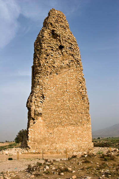 |
The city occupied about 300 hectares and was enclosed by a mud-brick rampart and a moat. Two axes, intersecting at right angles, divided the town into four equal parts. At their ends, these were marked by four gates - the Gate of Hormoz in the north, the Gate of Ardashir in the south, the Gate of Mithra in the east, and the Gate of Bahramin in the west. The four parts of the town were further divided into sectors, each surrounded by a separate wall in such a way that if the enemy succeeded in occupying one sector, he would have had to storm another rampart before taking over the next. A governmental district at the center consisted of a circle with a radius of less than 1 km; it served the purposes of the court and was also separated from the rest of the town by a wall. The intersection of the town's cardinal axes was marked by a tall tower, often called the Minaret. This square structure of rubble stone and gypsum still rises to a height of about 30 m. Each side of the lower part of the monument measures about 11 m. The minaret was ascended by an outside staircase whose steps decreased in width as they ascended.
One of the earliest Sasanid buildings extant, the tower may have been constructed as a monument to the king or as a memorial to the birth of the town. Some scholars have suggested that the building was used for religious purposes, perhaps with a fire kindled at its top. Others have assumed that it was an observatory post used by signalers who communicated with the sentinels of Qal'e-ye Dokhtar and were thus enabled to get the news of an enemy's impending attack in time to prepare the town's defenses. Legend also has it that the tower marks the landing site of a stone that had fallen from the sky.
At a short distance from the minaret, scattered stones mark the place where the Gur fire temple used to stand This structure was built of big, trimmed stones and rubble, joined to each other by iron braces. The temple consisted of a large, rectangular platform 82 m long and 66 m wide, paved with large stone blocks. In the middle of the platform was an elevated, quadrangular structure measuring 26 m on a side, and 8 m high. On this inner platform stood one of the largest of the Sasanid age's Chahar-Taqs, surmounted by a dome. The arches spanned 11 m, while the supporting column bases were 5 m thick. Although the majestic temple was the most conspicuous landmark of the ancient town, soaring high above everything else in the city, nothing of it has survived to this day.
Gur retained its importance throughout the Sasanid period as one of the major cities of the Ardashir-khurreh district. Under Piruz I Sasanid, the town was greatly expanded and began to be called Piruz. This name, however, was officially established only during the early Islamic period under Azod al-Dowleh, because its initial appellation (meaning "grave" in modern | Persian) had unpleasant connotations for the ruler, who would not have liked to hear that "he went to gur”. The prince also would have been influenced in his decision by the fact that by this time the city was more and more often called Jur in the Arabic manner, and being a staunch defender of Iranian national traditions, he could not but dislike it. Firuzabad used to be a populous stopping place along the road from Shiraz to Siraf, which for a long time was the main port for ships sailing to India and China. When the road was diverted, the town never recovered, and gradually turned into an agricultural center for the settled Qashqai tribesmen. The site of ancient Gur was inhabited as a small village as late as the Qajar rule. Today, however, it is completely derelict.
- Details
- Category: Museums of Shiraz