Copyright 2020 - 2021 irantour.tours all right reserved
Designed by Behsazanhost
Isfahan's Natural landscapes are a Paradise in the heart of Iran
Isfahan's Natural landscapes are a Paradise in the heart of Iran
Esfahan province is located in the center of the Iranian plateau. It occupies an area of more than 100,000 sq. km and stretches for about 540 km from east to west and for 400 km from north to south. Its easternmost town is Khur-Biabanak, westernmost, Fereidun-Shahr, northernmost, Aran, and southernmost, Semirom.
Mountains Of two Iranian major mountain chains, Alborz and Zagros, the Zagros rims the Esfahan province in the west and provides it with ruggedly mountainous and spectacular terrain. The Zagros stretches from the border of Armenia to the Persian Gulf, and then eastward into Baluchestan. As it moves southward, it broadens into a wide band of parallel, alternating mountains. It is drained on the west by streams that cut deep, narrow gorges and water fertile valleys. The land is extremely hard, difficult to access, and populated largely by pastoral nomads. The peaks of the Zagros range between 3,000 and 5,000 m. The highest of them are located in Chahar
The central mountains of Iran are a row of interrupted, rugged peaks stretching from Kashan into Baluchestan. These two mountain ranges are particularly notable - the Qohrud and the Bonan. The Qohrud mountains start in the environs of Kashan and extend into Kerman. Their highest peak is K
A number of rather low mountains and hills also dot the Esfahan plain, among them the highest point of Esfahan, the Soffeh Mountain (2.240 m). A beautiful park has been laid out on the slopes of this mountain. Two water springs - Dervish and Pachenar (or Takht-e Soleiman) - add to the beauty of the site. During the reign of Shah Soleiman Safavid, the royal recreational pavilion existed here. Of this, only the round foundation has survived. Unfortunately, nothing has remained of the earlier structures, most of which were ruined at the order of Shah Abbas I. Only some scattered stone masonry indicates the existence of the Seljuk fort that was known as Qale-ye Dezh. On the hill to the west of Soffeh Mountain, the ruins of the ancient tower called Takht-e Rostam can be seen. Some say that it was the place of the battle of Darius III Achaemenid and Alexander the Great.
Rivers Two of the most important Iranian rivers take beginning in the Zagros mountains - the only navigable Iranian river Karun and the Zayandeh-Rud, the main river of the central Iranian plateau that waters the fertile plain of Esfahan. There is little water flow in summer when many streams disappear. Water is, however, stored naturally underground, finding its outlet in qanats and being tapped by wells.
 |
Gavkhuni Swamp
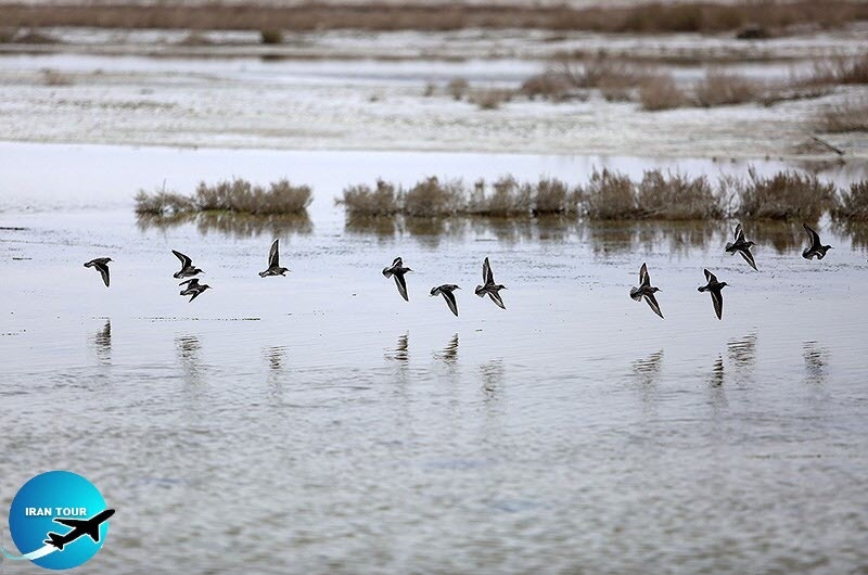
Located about 120 km southeast of Esfahan, the site is composed of the Gavkhuni Lake and the marshes of the lower Zayandeh Roud which extend for some 60 km upstream. The site occupies an area of about 40,000 hectares. The lake level is subject to seasonal variation, with floods sometimes extending as far as 50 km upstream in winter and spring. The lower Zayandeh-Rud marshes have formed in the floodplain of the river and are usually inundated in early winter, drying out gradually during the spring. Much of the marshland which once existed in the area has been converted to agricultural use to take advantage of the rich alluvial soil. The site is important for staging and wintering migratory water birds.
Qanats
Qanats are subterranean aqueducts to which most of Iran owes its very existence. The inhabitants of the Iranian plateau resorted to digging qanats at least 2,000 years ago in order to gain access to underground water supplies. This method, which has endured many centuries and has found its way from Iran to the Middle East, North Africa, Europe, and even Mexico, is still in use A qanat is tunneled at a great depth below the surface and may stretch for many kilometers. The process of construction is as follows. Experimental shafts are first sunk until spring is tapped in the higher ground. Then the laborer begins at the other end, where the water is required upon the surface, or at intervening points,
 |
Deserts
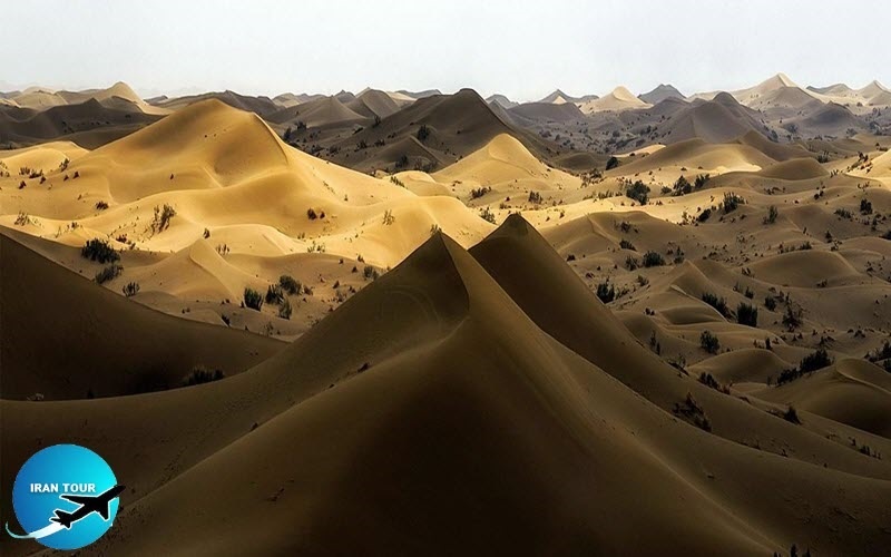
On the east, the Esfahan region is bordered by deserts. These deserts are mainly wastelands that once held great lakes. However, over the centuries the lakes dried up, leaving silt and mud, overlaid by a thin layer of crystalline salts. Three types of desert are distinguishable here:
The southern Dasht-e Lut, 320 km long and 160 km wide, is too hostile for life. Whether they consist of salt marshes or bowls of sand and dust, the Iranian deserts are extremely uninviting. Unlike the Arabian or Sahara deserts, which are haunts of the wandering tribes, the Iranian deserts are practically empty of nomad activity, except on the fringes to which a few herdsmen come in winter. The travelers can venture into the desert, provided that they have a stout vehicle (four-wheel drive) and a guide. The best time is between October and December, though the variations in temperature are considerable. One of the most interesting trekking routes is from Aran to Maranjab.
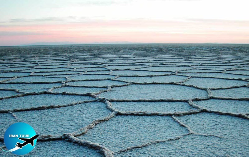 |
Salt Lake
Salt Lake is located to the west of Dasht-e Kavir about 60 km from Kashan. Its longest north-south diameter is 55 km and the longest east-west diameter is 57 km. Its approximate total area is 3,100 sq. km. Several minor rivers empty into the lake, among them the Qareh-Chai River, the Sur River, and the Jajrud River. The spot in the northwest where the three rivers empty into the lake is the deepest, forming a permanent lake of about 10 sq. km. The rest of the lake's surface is dry, being occasionally covered with water in spring. It is divided into hexagons which are formed due to the dryness of clay through evaporation, which eventually cracks and fractures into hexagonal shapes. The lakeshore has no plant Coverage. Its soil is a mixture of clay, salt, and sand. The land surrounding the lake is almost completely barren, and only scarce shrubs of tamarisk or salt tree sporadically grow. In the south section of the lake is an island about 2 km by 1 km rising at its highest point at about 80 m. It is called the Sargardan (Wanderer) Island.
Several Safavid caravanserais have survived along the lakeshores. They were built on the route that joined Esfahan with the Farah Abad complex of palaces in Mazanderan. The most important of them are the caravanserais of Maranjab, Sefidab, and Abbas Abad. Located in the oases mainly watered by the Qanats, these caravanserais served as places where travelers could rest and replenish their supplies.
 |
Flora and Fauna
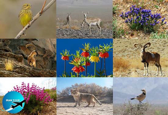
Topography, altitude, water supply, and soil determine the character of the vegetation of the Esfahan region. The Zagros Mountains are covered with broad-leaved deciduous forests, with oak, elm, maple, hackberry, walnut, and pistachio. Willow, poplar, and plane trees grow in the ravines, as do many species of creepers. Thin stands of juniper, almond, barberries, cotoneaster and wild fruit trees grow on the intermediate dry plateau. Dwarf scrub vegetation (Artemisietea herbaealbae Iranica) is common and is very diverse; in non-saline areas, a variant with many thorn cushions (Artemisietea herbalalbe astragaletosum glaucacanthi) is formed. There are acacia, dwarf palm, camel's thorn, and scattered shrubs. Under extremely arid conditions, a very open variant of the dwarf shrublands appears, the dominant species being sagebrush Artemesia herba-alba). Groves follow
The wildlife of the Esfahan region includes wolves, foxes, jackals, squirrels, mongooses, porcupines, badgers, rabbits and hares, leopards, lynxes, and cheetahs (the latter critically endangered). Wild goats, deer, endemic Iranian wild asses, and gazelles also abound. One of the most interesting creatures is the desert fox, which inhabits the driest and hottest desert regions and has adapted to this habitat by becoming entirely nocturnal. Rodents are ubiquitous, and about a hundred varieties of lizard are found. The four-toed or steppe tortoise inhabits areas of Artemisia steppe.
The birdlife of the region is varied, with magpies, blue rollers, bee-eaters, hawks, choughs, blue jays, red grouses, larks, and crows being the most common. Flocks of pigeons are to be found everywhere. In spring, the storks nest on the gateways and ruined minarets of some of the towns, and Iranians call them hajji, because they say that they have spent the winter at Mecca, and are, therefore, entitled to the honorable sobriquet of “pilgrims”. Among the less common birds are quails, partridges, falcons, vultures, black kites, and golden eagles. The rivers, streams, and swamps harbor ducks, teals, snipes, wild geese, herons,
The reptile life is chiefly represented by lizards such as huge warrens, which abound in the most desolated desert areas. Snakes (rarely poisonous) are sometimes found in gardens, attracted by the water. Iranians have a superstition that these reptiles are in the habit of guarding
National Parks and Natural Protected Zones
The Esfahan province has one national park and two large protected areas that have been created to preserve the wildlife of the region. They are generally closed to the public and can be visited only with an organized tour.
Kolah Qazi National Park is situated about 25 km south of Esfahan. It occupies an area of 41,184 hectares and consists of a vast steppe, known as the White Desert, affected by the desert on the east and the Zagros ecosystem on the west. Plant species include almonds, figs, Turk terebinth National Parks and Natural Protected Zones The Esfahan province has one national park and two large protected areas that have been created to preserve the wildlife of the region. They are generally closed to the public and can be visited only with an organized tour.
Kolah Qazi National Park is situated about 25 km south of Esfahan. It occupies an area of 41,184 hectares and consists of a vast steppe, known as the White Desert, affected by the desert on the east and the Zagros ecosystem on the west. Plant species include almonds, figs, Turk terebinth maple, rhubarb, primrose, poppy, salvia, camel's thorn, etc. Wild sheep (Ovis
- Details
- Category: Esfahan Tourism