Copyright 2020 - 2021 irantour.tours all right reserved
Designed by Behsazanhost
Zayande Rood River and its Historical Bridges
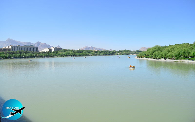
Zayandeh Rood or Life-Giving River and its Historical Bridges
The Zenith of the Connection between Art and Nature
This river originates from Zard
 |
Thus, a delegation was dispatched there under the patronage of the king, but it was stopped after the king's death. Another plan, that was also studied during the reign of Shah Abbas I, was to reserve water by designing a dam on Zayandeh Rood. During the reign of Shah Abbas II, the project was resumed again by a French engineer, Duchene, but no result was obtained Once more, the design was appraised during the reign of Shah Soleyman; however, his powerful minister Sheikh Ali Khan, who owned the property of many large cultivated lands, encouraged the king to dispense with the project. (A proverb states: The king forgives, but Sheikh Ali Khan does not). Finally, in 1948 A.D., under the supervision of an English consulting company, a tunnel was dug (2840 meters in length) at the elevation of 2500 meters above sea level that conducted Kooh Rang water to Zayandeh Rood. In 1985 A.D., the second tunnel exploded with a length of 3000 meters, at about 300 meters distant from east of the first one. The third tunnel was inaugurated to convey water to the east of Yazd province.
The total length of Zayandeh Rood, on its wavy course, is about 420 kilometers which has changed it to one of the best of Iran's rafting rivers. This river finally leads to the Gav Khuni Marsh. Since the time of the Sassanids to the present, some bridges and dams built over the river, so the banks of the river have been always an unparalleled host to people. At the western extreme of the city, there are a number of ditches (Madi), from the upper lands of the river which play an important role in the irrigation of the urban and rural lands, moderation of the temperature, and nourishment of underground waters. For further information about bridges, see the historical bridges.
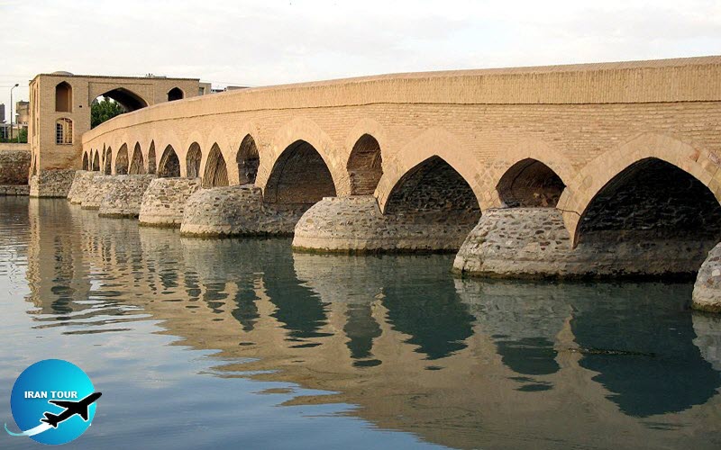 |
Historical Bridge of Shahrestan The Oldest Hydraulic Structure on the Zayandeh Rood
This bridge which dated back to the Sassanid Era (224-651 A.D.), is in the vicinity of an ancient hill named: Ashraf that according to supporting evidence, is the same site as Sarouyeh, the pre-historical city site (now 3 kilometers distant from east of Bozorgmehr Circle). While standing on the northern extreme of the bridge and looking at the body of each side, at first glance the striking difference between the bridge and the other historical bridges of the Zayandeh Rood attracts attention. This distinction refers to existing horizontal and vertical parabolic curves, of which the former links to the curved plan and the latter to the curved view of the bridge top. The horizontal curve turns the bending of the plan towards the west (the opposite direction of the water flow that is from west to east) to increase the contact area of this bridge in connection with the hydraulic pressures and decrease the stress per unit of area. Besides, it functions as a structural model of a simple beam devised with a prefabricated deflection in the opposite direction of loading.
The vertical curve acts as a less sensitive top line than a straight one, which in the case of the occurrence of a sudden flood, is again like a simple beam with a deflection upward. To neutralize the gravitational force of moving loads, and to analyze a part of them towards both ends of the bridge, there are two resilient beds (the embankment of the earth on both ends). In addition, the shallow open canal, on the top
The bridge has a length of 107.8 meters on the curved center line and is so meters (average) wide. The span of this bridge was designed at two different levels. On the lower level, there are 13 sluices and on the upper one there are galleries in smaller sizes, which have multi-functions as follow:
1. They make evacuation of a sudden flood faster and protect the crown of the bridge (the top and midpoint) against overflow damage.
2. They give easy access to restore the vaults and arches.
3. They provide suitable and cozy spaces for sitting and resting.
4. By these galleries, the span of the sluices has decreased so that their rise and masonry consumption (baked bricks) have reduced to render a less expensive and more
As a visitor, when we look at a hydraulic structure, we should bear in mind that its long life is directly related to the stability of its substructure, or foundation to which usually a major part of the project expenses should be allocated. That is why the designer found, at this site an exceptionally natural rocky bed (the Zayandeh Rood has almost a sandy bed) with perfect assurance for further unequaled settlement of the location of the superstructure, so this item also can be emphasized as one of the most important reasons for the longevity of Shahrestan Bridge which has remained very stable for at least 15 centuries.
At present, the river bed has been diverted about a hundred meters towards the south, and the surrounding area of the bridge is like a pond with stagnant water that causes less erosion on the hydrodynamically shaped piers of the bridge. The pond can be fed with a concrete canal system on the southwestern part of the bridge.
In recent years, on the southern part of the bridge, for holding fairs, the International Exhibition Organization of Esfahan Province has set in a huge
One of the most attractive spectacles is on the southern end near the
Another view appears if you stand in the middle of the bridge with a little diversion towards the south, and face the northwestern horizon. In this way, you find a small brick dome with a green flag on it. This is the tomb of 'Al-Rashed-
Concerning the alcoves (chambers) of this bridge, on both sides of the
1. Due to the topographical discrepancies between both ends of the bridge (the northern bed is deeper), there is much more water discharge. Thus, more stability can be obtained by increasing the gravitational load. 2. In earlier times, it was used as a station for toll payment by caravans. 3. It was a temporal chamber for kings or rulers to take delight in watching the ancient festival of Ab Pashan for a couple of hours (see the details on Khajou Bridge).
The bridge has been renovated four times during its existence: during the reign of Al-e-Buyid', the Seljuk, the Safavid, and the last one about 15 years ago by Esfahan Municipality under the supervision of the Cultural Heritage Office.
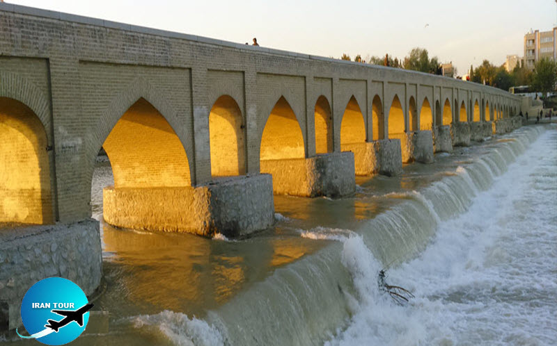 |
- Marnan: A Historical Bridge on The Western Extreme of Esfahan
Etymologically, Marnan was Marbin and Mehrbin (vision of the sun) which refers to the name of its residential area. With a glance at the structure of this bridge, one can find that the piers of Marnan are likely to be the piers of Shahrestan Bridge, with a similar elliptic plan made up of blocks of stone fixed with clay and lime powder.
About the upper level of the bridge, we can also find some similarities to
But about the points of difference, we can talk about the various shapes of the upper and lower level of arches between the two bridges. The curves of the Maman arches are based on the Safavid era style, but in Shahrestan, they are! similar to the Sasanid era style. This is why we can reach the point that the upper part of Marnan, which was made of baked brick, dates back to the Safavid era Referring to some of the origins we find that, the bridge was rebuilt by Khale Sarfaraz, the Armenian administrator who was elected after the death of his father, Khaje Nazar, to the position in 1636 A.D. The bridge is 186 meters long and 4.8 meters wide, with 17 sluices and 14 galleries (floodgates) on its upper level.
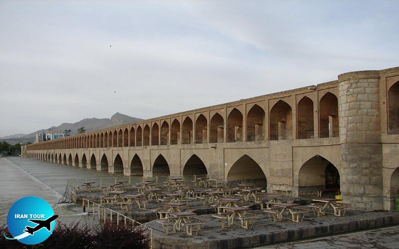 |
-"Si-o-Se-Pol Bridge' The Axial Element of Physical and Cultural Connection
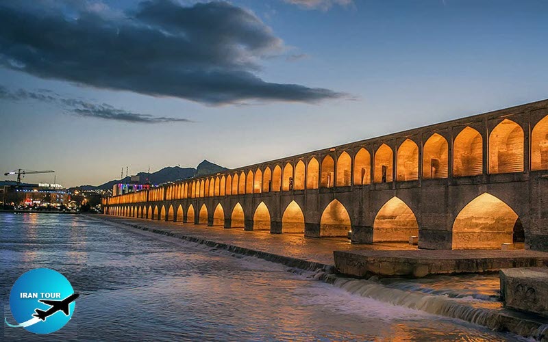
The historical bridge of Si-o-Se-Pol' (33-sluice bridge), which dates back to 1591-1597 A.D. is 295 meters long and 14.7 meters wide. It is the largest
It has recently been revitalized with a stone pavement at the ends, ramps, and a total land arrangement. About 35 years ago, a concrete slab was added over the original stone pavement to reinforce the bridge, but now it is below the asphalt laver. The other items of restoration were: designing an additional vault for the absorption of humidity in connection with the northern side (on the southern side another one exists), expanding land arrangement by redesigning the public area pavement, removal of visional obstructions around the bridge sides and installment of an appropriate up-to-date lighting system that illuminates the bridge, thus, making it much more spectacular at night.
The main role of this bridge is to connect the northern Chahar Bagh (central boulevard of the city designed in the 1/th century) to the southern one. Now it is only for pedestrian use. According to the latest inspections on the piers, it was discovered that there are pile foundations below the piers, substructure, for the stability of the bridge, superstructure. The system of pile-driving is very prevalent, nowadays, by using prefabricated piles driven by heavy-duty machinery, but the utility of this system used four centuries ago) is an amazing point and shows the great technical innovation. This process was done by digging wells to find a stable base, and after covering the interior surface of the wells with earthenware pipes (about one meter in diameter) from the bottom to the top, then filling them with stone blocks, mud, and lime powder up to the normal level of the river-bed. The system was able to carry the burden of the loads with both, the stable base directly and indirectly by a friction method.
 |
On the other hand, on examination of the river-bed plan, it was found that there is a maximum curvature towards the north showing that during the building of the bridge, they had settled the structure on the northern side of the river-bed (the site did not need a lot of drainages) and after the completion of the structure, the river-bed was diverted to the north. When a visitor reviews the length of the bridge, he may ask himself "Why is it so long? (by the knowledge of this fact that a bridge is normally settled on the narrowest bed of the river, not the widest one). In response, it should be noted that the site of the bridge was determined by the central boulevard (designed on north-south) to connect it from the northern bank to the southern bank of the river. The other item involved in this planning was to avail a very wide and shallow riverbed for granting a pleasurable atmosphere in the center of the city.
If you stand at the northwestern side of "Si o Se Pol' and look at the golden bridge, the pale green river, the hump-shaped top of the Soffeh mountain in violet and gray, and turquoise sky background, you will be lost for a couple of seconds in admiration of the patron, designer, and builders.
This bridge was built and designed by "Ostad Hussein-e-Banna Esfahani, Who is generally unknown to most people. He was the father of Mohammad Reza Esfahani, the designer, and builder of Sheikh Lotfollah Mosque (verily, from such a father such a son is expected).
Amongst the other names of this bridge, we can mention Chahar Bagh Julfo and Allahverdi Khan. The last one is the name of Shah Abbas's most faithful and favorite chief commander of the army whose portrait is painted on the left-hand side of Shah Abbas I, on the northwestern panel of the throne room in Chehel Sotoon Palace. He was in charge of the provincial governorship of Fars province and he patronized this bridge.
 |
This bridge has two cloistered lobbies on the upper deck, each one is about 80 centimeters wide to protect passers-by from direct sunlight or probable rainfall. Besides, each of the existing false arches, on both sides, divides this long and narrow lobby into separate balconies facing the river with a fully pleasurable atmosphere for a tired wayfarer. As we mentioned before, the floors of these lobbies were also at a lower level, and the ceilings were not so low before.
Another outstanding point, which calls the attention of the pedestrian, is that on both sides there are a number of false arches, about 206, with a width of 2.6 meters, and one out of five is completely open, or has a small portal. If a pedestrian moves on foot or by a horse with a steady speed, every ten to four seconds, respectively, s/he is able to have a visual or mental relationship scene graphically with the landscapes on both sides during the movement. Aesthetically, the afore-mentioned case is only an architectural aspect, but structurally they function as a reducer of the wind force on the
Si-o-Se-Pol', on its pathway, has two water basins (Sagha-Khaneh) to quench the thirst of people crossing the river and eight stairways. The total number of multi curved (haft-
On the western view of the bridge, there are two alcoves (special sites for VIPs), as well as at the lower part of this bridge, a total number of 23 chambers with different sizes for having fun and pleasure, but nowadays they are used as teahouses.
The total number of sluices is 33. harmonious to its etymology, and there are many different narrations and interpretations about the number proverbial among all, but the majority of them based on cultural aspects. According to the Zoroastrian belief, one can enter heaven by the way of
This section subsumed under a title that pointed to the main role of this bridge as a connector with both physical and cultural functions between both banks of the river, and the relationship among Julfa (the Armenian district) and other Muslims' quarters.
The masonry on the lower parts are stone blocks joined together with clay and lime powder, and on the upper parts, it is made of high-quality baked bricks fixed together with a kind of lime-containing (calcareous) plaster gypsum.
The Bridges over Zayande Rood
Warning: No images in specified directory. Please check the directory!
Debug: specified directory - https://irantour.tours/images//Isfahan/
 |
-Khajou Bridge The Multifunctional Hydraulic Structure Etymology of Khajou Bridge
Some historians believe that Khajou derived from the word Kha'je, which means courtiers or nobles, and maintain that during the 17th century A.D. these dignitaries were living in the quarter next to the bridge, and that area because of its vicinity to the river and green foliage enjoyed a pleasant climate. This is why there is a multitude of other names for it such as
Functions of the Bridge
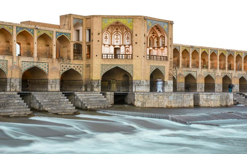
Khajou Bridge is a double-decker bridge; the upper deck which designed for a fast walker crossing the river and the lower one for recreation.
A Farsi poem composed of a distich upon the completion of the bridge mentioned that the king, who ordered its construction, was Shah Abbas II. This poem asserted the multifunctions of the structure such, as the bridge, the barrage, and the lake. It is worth mentioning that we are now the eyewitnesses to the glorious past of our ancestors whose structural product is a unique masterpiece of the mid-seventeenth century and representative of an excellent, expressive sample of analysis, design, and construction for a hydraulic structure.
Physical Aspects
The date of its completion is 1655 A.D. with a length of 133 meters, a width of 12 meters, and a total number of 21 sluices that span the river. In addition, it is the only bridge over the river, Zayandeh Rood, decorated by polychrome tiles on the upper external and internal arches, filled with many floral and geometric designs. This tilework embellished the spans of cloistered lobbies on both sides, similar to an eternal garden for wayfarers, and has suitable corridors (devices) that protect them against the radiation of intense sunlight and probable rainfall.
 |
Functions of the Alcoves
In the middle of the bridge, we observe the gorgeous glorious alcoves on both sides, chambers where a king or ruler used to sit. Structurally, they increase the stability of the hydraulic structure in the middle (its critical point), with their additional imposed dead load and service load that augment the structural section modulus of the bridge. Also, the upper-deck chambers on both ends of the structure might have functioned as the toll stations for the passage of caravans.
At the lower elevation, there are four separate spiral stairways leading to the alcoves. Inside the alcoves, the walls are decorated in a marvelous manner, with mural paintings and plasterwork on the curved surfaces. It should be added that. in the course of history, a famous pre-Islamic festival called; Ab Pashan (water splashing), held in the mid-summer of every year. On this occasion, people gathered on the river banks and settled next to the bridge for a couple of days, splashed water on each other, and believed it would safeguard their health against harms (what
Side Effects on the Hydrology of the Area
In addition to connecting both riversides, the bridge served as a very important barrage piled up water as a reservoir on its western side (running water direction is from west to east), thus feeding the underground-water reservoirs and raising the level of the water tables, as a result by elevation of water surface of wells around especially by the end of summer. At the same time, the level of the water surface and lake capacity was controlled by the use of wooden panels fitted into special cubic grooves denied and located in the
 |
- Stone Lions of the Bridge
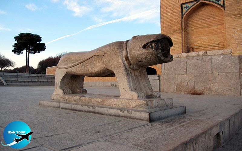
On the eastern facade, there are two stone lions on both sides. Inside the mouth of each, a carved face of a warrior protrudes. At present, they function as two safeguard elements for the historical monument, but their function was originally the tombstones of warriors who were martyred (a person who is put to death or suffers greatly for his ambitions) on battlefields. In such cases, it was common to use a freestanding stone lion instead of a flat stone as a tombstone. On closer inspection of the bodies, the low carved shapes of gymnastic apparatuses and warfare equipment such as shield bow, mace, and sword can be observed.
Hydraulic Specifications
When we stand on the lower
It can be observed that in the case of a flood, water flows over the stairs and the extra energy will be dissipated. There is a diversion from the axial flow of the river during its passage through the twin spans in the middle of the bridge on both sides of the alcoves. In this case, when these critical waves contact the normal flow, through the adjacent spans, again the extra energy is dissipated. With respect to the fact that in the middle spans of the bridge the flow velocity is higher than the normal spans, it can be seen that the intensity of kinetic energy, due to the water flow is more than the passing flows through the other spans.
In relation to the existence of the stairways on the eastern view, they perform different functions as buttresses (retaining walls, which mostly in hydraulic structures, designed in a prismatic form on opposite sides of the reservoirs) to protect the structure against sliding due to the hydrodynamic forces. The style of the steps gives an optimum site for people to sit on, as a recreational place with a total capacity of over 500 people. In addition, their other utility is to dissipate the energy of running water by analyzing the hydraulic force into horizontal and vertical components (gravitational force), which decelerate flow and slow down erosion while passing.
The Poetic Atmosphere
 |
A visitor, with a poetic talent, recalls the famous Farsi poem which states
Sit by the brook, watch your passing life,
Hints moving water, how transient while.
Or
Life is passing like a boat moving,
Seems standing, still no moving.
Labeled Masonry (Construction Materials)
When you look closely at the lower blocks of stone, you can distinguish some low-carved icons that are not easily recognizable. You may think they are related to the size, similarity, and stone volumes that were used. But these icons, so similar to the Greek Alphabet, belonged to workshops (contractors) and as the label of quality certification for the texture of each block because the lower materials should be more durable and resistant without any joints or laminations against moisture, leakage, and friction due to water flow.
Additional Views
On the northeastern part of the bridge, there is a twin-vault monument with latticed windows around it. When looking through them, two gravestones belonging to Professor Arthur Upham Pope, the famous American orientalistIranologist, and his wife who dedicated a major part of their lives to academic research by writing many volumes of books introduced Iranian civilization to the world. In 1960 A.D., their mere request from the authorities, in response to their sincere services was to be allowed to be neighbors of this bridge forever.
Perhaps the best description is that Khajou Bridge is one of the most significant Iranian architectural products. It actually reflects the zenith of victorious glory of form and color in the framework of a structure. We find Khajou Bridge as a unique sample of man's achievement.
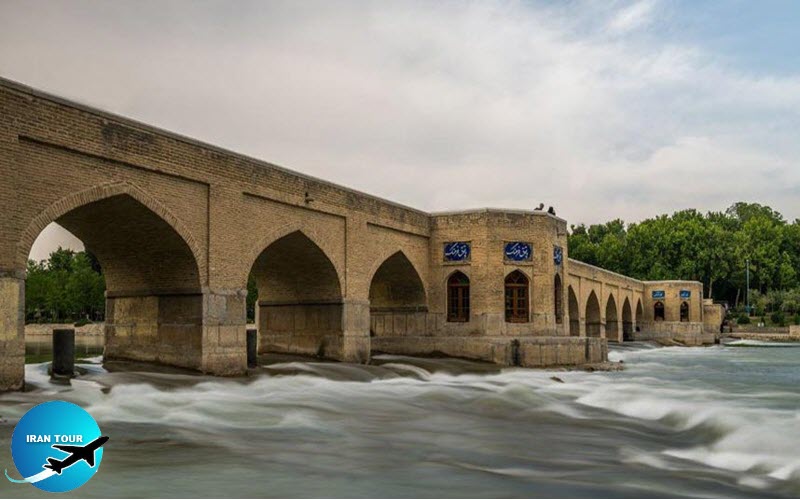 |
- Juie Bridge The Only Private Historical Bridge on the Zayandeh Rood Equipped with an Aqueduct System
The local people call the bridge Choobi (wooden) because of its easier pronunciation.
- Details
- Category: Museums of Esfahan